BMC Elections
- Past BMC Election Results
- Know your Booth Location
- Standing Committee Members
- BMC Elections 2017 Delimitation
- New Ward List Civic Elections 2025
- New Wards Maps for BMC Elections 2025
- BMC Election 2025 Date
- CEO Maharashtra
- Know Your BMC
- BMC News & Updates
- Wards
- Candidates
- Mumbai Corporators
- Advertise
- Contact
- Volunteer
- Privacy Policy
3D mapping of Worli completed by BMC, a project one of its kind in Mumbai
- by Webdesk
- 25 Sep 2021
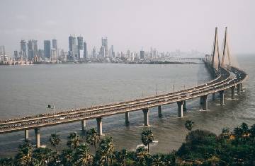
A three-dimensional (3D) development plan and the master plan of the Worli area called a three-dimensional (3D) geospatial city model have been prepared by the Brihanmumbai Municipal Corporation (BMC). This is a digital 3D map covering all the parameters of the area and has a panoramic view of 360- degrees. 10 square Kilometres, consisting of Worli’s whole G/South ward is covered under the project.
This project will be working as a helping hand for different development projects and policy framing in the area which includes planning of infrastructure, natural disaster management, analysis of citizen safety environment and looking into public amenities.
This project was proposed by Cabinet Minister Aaditya Thackeray, representing the Worli Assembly after which the Brihanmumbai Municipal Corporation (BMC) took it in partnership with Genesys.
“In this ever-growing technology world, it becomes very important to upgrade city infrastructure. To meet the ever-growing demand in the 21st century it is very important that urban governments can see their cities in 3 dimensional to get a perfect 360-degree view,” stated G/South ward Brihanmumbai Municipal Corporation (BMC).
This 3 dimensional (3D) geospatial city model will help in detecting analysis, will have the capacity to get the information on unauthorized and illegal settlements, classifying the types of buildings, planning of a detailed infrastructure of roads, bridges, flyovers.
Image Courtesy: 3D mapping of Worli completed by BMC, a project one of its kind in Mumbai
Related News

This article is based on publicly available information from credible sources (as mentioned above) and has been restructured using a combination of AI tools and manual editorial inputs to enhance clarity and readability. While we aim to maintain accuracy, there may be unintentional errors or misinterpretations. If you come across any incorrect or misleading information, please report it to us at info@bmcelections.com.
Copyright © 2026 All Rights Reserved | BMC Election